The noble trees approach. Slender and fair, the herald promises enlightenment.

Soon the trees surround the walls of stone. Is this beneficence or menace? Continue reading
The noble trees approach. Slender and fair, the herald promises enlightenment.
Soon the trees surround the walls of stone. Is this beneficence or menace? Continue reading
 No trip to Angkor Wat would be complete without visiting the toilet. Sadly, the ruins themselves and our guidebook are bereft of signs indicating where and how the long-lost inhabitants of this ancient and mysterious temple handled their waste. But there’s no lack of signs just a notch to the south, at the clean, well-stocked, and (for ticket-holders) free public toilets.
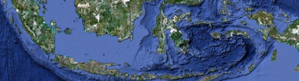
 [Click on the photos to enlarge them.] The Tonle Sap is a lake-and-river combo. It’s remarkable because it reverses flow seasonally. During the dry season, the lake and a lot of fish flow into the river, but, during the rainy season, the river reverses and flows massively into the lake. The lake goes from large to huge, and some places go from dry to several meters under water. People and other living things have to cope with this change.
Tourists staying at Siem Reap, in addition to gandering at ancient temples such as Angkor Wat, can visit the resulting ‘floating villages’ and flooded forests. We hired a boat that carried us through a channel of submerged trees to one such village, called Kampong (or Kompong) Phluk.![]()

As you can see, the buildings aren’t floating but are built on stilts. Our experience there would have been incredibly different in the dry season, because these buildings would have loomed high above dry ground, and entering them would have required quite a climb. I recommend that you Google (or whatever) Kampong Phluk to see just how tall they are.
There’s a dog lazing on the platform in front of this house:

The boat on the left is a floating store, making the rounds.

Here’s a school:

Amazingly, there were a couple of enclosures for pigs:

In our short time there, these boys demonstrated a variety of ways to play on the water in metal tubs:

The most impressive sight, for me, was this temple. It sits on solid ground, along with a broadcast tower. It must be resting on a huge pile of dirt; I imagine that people ‘shore it up’ each year when the water recedes.

The village offered tranquil canoe rides through a small nearby forest. All of these would be tall trees during the dry season.

Here’s one of the guides; all of them were women. We guessed that this was one of many ways Cambodians tried to use tourism to increase dignified employment for women.

Not far beyond the flooded forest, the zone of trees and settlement gave way to a vast, open lake. This is the edge:
This short video gives a sense of what the visit was like, including the sounds:

[Click on the photos to enlarge them!] The Bayon is part of the Angkor Wat region – just up the road from Angkor Wat proper. It’s inside an area called Angkor Thom.
What makes it noteworthy are the scores of faces carved on towers. A common hypothesis is that these are composites of Buddha’s face and that of the king who had the temple built.
To me, one of the striking aspects of the faces is that they all look outward from a great height. The interior of the ruins contains a variety of decorations – but none of these visages. Continue reading
 [Click on the photos to enlarge them.] The tricky thing about visiting Angkor Wat is that Angkor Wat per se is merely one ancient site – albeit a really large one – among many near the small city of Siem Reap. So these are photos and video of Angkor Wat per se – later posts will feature other sites in the region we call Angkor Wat.
Moreover, Angkor Wat proper is not the temple that I, at least, picture when I think of “Angkor Wat”: crumbling as the jungle overtakes it. Photos like this are misleading: Continue reading
